
Harewell (Summerbridge) Rural Maprun – Easter Friday 2 Apr
Good Friday Harewell – Entrants List
This is a 2 hour score event on the footpaths through fields and woods from Summerbridge in Nidderdale. It visits the opposite side of the valley to the event at New Year. The map is the Ordnance Survey 1:25000 map but has been blown up to 1:15000 and a few corrections overprinted. It is the usual score format – there are 30 controls marked on the map and you visit as many as possible in the two hour period with penalties for being over time. You will need to have Maprun6 (it will work with MapRunF too) installed on your (fully charged!) mobile phone in order to register your visit to each control (sorry no lampposts available). You must, please, take care to stick to footpaths (or the minor roads) and use gates and stiles – don’t upset my neighbours. Expect some muddy conditions and paddling small becks.
PLEASE CHECK HERE BEFORE TRAVELLING. In the unlikely event of severe weather the event may be postponed.
ROUTE TO START. Please note this will not be signed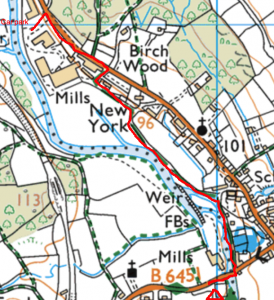
Exit the industrial estate and go right for 300m before turning into housing area and follow bridleway left for 600m. At the road take care crossing to the footpath on the far side and go across the bridge and 100m to the small pavilion where maps are available.
START BRIEFING:
Maprun The map is called Harewell, and the MapRun called ‘HarewellEaster21’. It can be found in the UK, North Yorkshire and then PateleyBridge folders. The PIN to start will be on the back of the map.
Paper map is the OS 1:25000 map blown up to 1:15000.
Map legend at https://www.ordnancesurvey.co.uk/documents/25k-raster-legend.pdf
There are a small number of corrections overprinted in purple:
– Crosses mark uncrossable or not permitted routes.
– Dashed line indicates a frequently used path.
Controls If you are at a control point but it does not register on Maprun then just continue and we can look at your route afterwards and credit you with the control.
Permitted paths
– Public roads marked in yellow or brown B roads where there is a footpath. Purple crosses indicate a B-road without footpath is prohibited.
– Rights-of-way, footpath or bridleway indicated by green dashes. Purple crosses indicate a few places where these are not passable.
– Frequently used paths indicated by purple dashes – where these closely parallel rights-of-way use the purple route.
Take care crossing roads – especially the B road by the start
Do not use any other tracks or paths than those indicated as rights-of-way in green.
Take especially care map reading through farms and hamlets.
Crossing walls and fences use gates and stiles – I don’t know of anywhere on these paths without proper crossing points.
Show consideration to other footpath users – the area may be busy – remember 2m
Beware some paths are very muddy with trip hazards and obstructive vegetation
In normal conditions all streams are crossable but wet feet may be unavoidable.
Farm dogs – loud but usually chained are Harewell Hall but may be loose at Heyshaw.
PAYMENT:
£3 per person. A card machine will also be available on the day or you can pay with cash but no change can be given.
Payment preferably by bank transfer to the following account:
Account Name: Claro Orienteering Club BIA
Sort code: 30 93 91
Account No: 00419604
Reference: Easter and Surname
ENTRIES: Please use the Google Form to enter. Entries close Monday March 29th.
JUNIORS: Juniors under 16 must pair up with an adult.
DIRECTIONS AND PARKING: If the weather forecast is poor please check this website that the event is on. Parking is in the New York Industrial Estate at the north end of Summerbridge. If you are going through Summerbridge towards Pateley then it is on the left as you leave the village. Beware car gps often tries to send people via the old entrance 300m earlier into a residential road which now has no access. There should be someone directing parking but if not please park in a parking bay in the north, new, end of the industrial estate but not in the spaces directly outside the individual units.
STARTS: Will be 10-10.30am. The start and finish control are about 20 minutes walk from the car park near the bridge in Summerbridge.
The start briefing will be on the back of the map and will be posted here a couple of days before the event. Pease read this carefully to be clear about how this novel format works.
TOILETS: There are no toilets at the event but there are public toilets in Dacre Banks (north side of road by surgery) and Glasshouses (by crossroad).
DOGS: Please do not bring dogs – many fields have sheep.
SAFETY: Participants take part at their own risk and are responsible for their own safety. All participants must return via the finish control so we know you have finished. The organisers mobile phone number will be on the back of the map.
ORGANISER: Liz Potterton 01423 780783 or fixtures@claro-orienteering.org.uk