
Winter 2021 – Street MapRuns
The Winter Blues
DUE TO LOCKDOWN 3, THESE EVENTS WILL MOVE TO INDIVIDUAL MAPRUNS UNTIL FURTHER NOTICE. WE WILL REVERT TO TUESDAY EVENINGS AS SOON AS IT IS POSSIBLE TO DO SO. YOU DO NOT NEED TO ENTER WHILE THE MAPRUNS ARE INDIVIDUAL. THEY ARE FREE TO ALL.
UNTIL THEN IT IS PLANNED THAT EACH MAPRUN WILL BE RELEASED ON THE DATE BELOW FOR YOU TO ENJOY. MORE DETAILS BELOW.
EACH MAPRUN WILL BE AVAILABLE ON THE MAPRUN WEBSITE GOING FORWARDS, SO IF YOU FEEL IT IS TOO FAR FROM YOUR LOCALITY AT PRESENT, THERE IS NO NEED TO HURRY TO RUN IT DURING THIS LOCKDOWN.
Runners must apply their own discretion as to how and when they should use the course having regard to the prevailing conditions, and the BOF COVID Guide to Participant Conduct. They should exercise due caution on roads and comply with the Highway Code. Unfortunately, as the events are on public roads, it is recommended that juniors (Under 16s) should only take part if they are accompanied by an adult in that child’s bubble.
Events Planned in the Winnter 2021 Series
| Release Date | Venue | Grid Reference | What3Words | Post Code | Organiser | MapRun Name | Map for you to Print |
| 12 Jan 21 | Hookstone Chase, Starbeck | SE333564 | breakfast.basically.darting | HG2 7HB | Ruth Ker | Hookstone Chase | MAP |
| 26 Jan 21 | Knaresborough North | SE350574 | lush.delusions.deduced | HG5 0JY | John Lebeter | KnaresboroughFarNorth | MAP |
| 9 Feb 21 | Rossett Green, Harrogate | SE303542 | movie.mole.tribes | HG2 9AX | Richard Kirk | RossettGreen | MAP |
| 23 Feb 21 | Ripon | SE317709 | unfit.bitter.imposes | HG4 1NH | David Day | RiponEast | MAP |
| 9 Mar 21 | Wetherby | SE404480 | pans.jabs.bulge | LS22 6AN | Liz & Will Drewe | WetherbyEast | MAP |
| 23 Mar 21 | Hookstone, Harrogate | SE320541 | winner.acted.from | HG2 8PN | Quentin Harding | HookstoneLong
HookstoneShort |
NB. The MapRun events are PIN protected until the date of release of the event.
The location of all the events can be viewed on this MAP
Hookstone Long (60 minute) & Short (45 minute) Score
6th and last MapRun of the Winter Street Series from Tuesday 23 March 2021
For this last event of the series, for a change you can enjoy some off road running, breath in the air and let your senses rejoice. It is not recommended you do this event in the dark!
Courses: There are two courses available for this activity: a 45 minute Short score which can be done all off-road and can be done safely with children. The longer 60 minute score includes all the controls from the short but also heads into adjacent streets where road care needs to be taken. Download the map to the new MapRun6 or the previous MapRunF app on your phone from the ‘Select Event’ folder of maps via UK, North Yorkshire, Harrogate, HookstoneLong or HookstoneShort. It will be PIN protected until early a.m. on that Tuesday so you won’t be able to use the “Go to Start” function until that time.
The courses go into the woods, the GPS cover was checked in March but as leaf cover increases this may be insufficient to register controls accurately. If this is the case, move on to the next control and award yourself the control retrospectively using the HITMO facility in MapRun.
Map: Print yourself a paper map. The map is a combination of the latest Hookstone Woods map with the surrounding area supported by the usual LampO style map. Please note the different scales on each course and the unconventional direction of magnetic north.
Parking/start: There are multiple sheffield stands to securely lock bicycles near to control 1. If you need to drive, park at the public car park opposite the Harrogate Squash Centre.
The start/finish is in the corner of the fence to the show ground where signs say ‘Education Gate’.
Course and safety information: None of the ‘controls’ are LampPosts, you have real pictorial control descriptions for you to practice on. If you want to look any up, this GUIDE will help.
The short course remains within the parkland area. This is used extensively by the public for the purposes of exercising themselves, their dogs or their bicycles. Be aware of all of these and please try and get on with each other. Come the summer, undergrowth should be considered when making route choice.
The long course covers roads, there is a pavement available in all cases but not necessarily on both sides of the road. The road across the top of the map is the busiest but still has a 30mph limit.
The Harrogate Fitness Club has a balcony cafe which at some time in the future be open for business.
May you run, skip and jump,
Quentin
Wetherby East (60 minute score)
5th MapRun of the Winter Street Series from Tuesday 9 March 2021
Download the map to the new MapRun6 or the previous MapRunF app on your phone from the ‘Select Event’ folder of maps via UK, North Yorkshire, Wetherby, WetherbyEast. It will be PIN protected until early a.m. on that Tuesday so you won’t be able to use the “Go to Start” function until that time.
Map: Print yourself a paper map. For an authentic experience, do not look at it until you are ready to start. The scale is 1:7500. This course is a modified version of the Dec 2018 LampO where the winner collected 23 of 29 controls in 45 mins. For this MapRun there are 27 controls, the start/finish has been relocated and it is a 60 minute score course not the normal 45 minutes.
Parking/start: It is recommended to park at the Wilderness Car Park next to the River Wharfe (LS22 6RF). The start is adjacent to the Band Stand in the NW corner of the car park, next to the river.
Course and safety information: All the ‘controls’ are LampPosts. You may be required to cross the A661/Harrogate Road in the town centre and/or Deighton Road outside of the town centre – both can be busy – please use caution and use pedestrian crossings where available. Please be aware of your surroundings, members of the public, and other general street scene hazards encountered in an urban environment. If running in daylight the old railway lines (triangular are in the centre of the map) can be used (look out for mountain bikers!). If running at night these are best avoided and the course was planned avoid the need to use this area, other than to cross it.
Post-race: I believe the Wetherby Whaler are taking walk-up orders, but pre-ordering is also possible. Additionally, Sant Angelo make some delicious pizzas!
Have fun!
Will Drewe
Ripon East
4th MapRun of the Winter Street Series from Tuesday 23 February 2021
Download the map to the new MapRun6 or the previous MapRunF app on your phone from the ‘Select Event’ folder of maps via UK, North Yorkshire, Ripon, RiponEast.
Print yourself a paper map from the table above and you are ready to go.
The start and finish are on Alma Gardens. ‘What Three Words’ unfit.bitter.imposes There is plenty of parking on Low Mill Road.
There are some off road paths but normal footwear should be OK; controls are mostly lampposts but also some other point features; the area includes the A61 bypass but there are safe underpasses marked on the map + a crossing next to a roundabout with a pedestrian island – take care here! There is a footpath alongside the B6265 Boroughbridge Road, please use this.
David Day
Rossett Green
3rd MapRun of the Winter Street Series from Tuesday 9 February 2021
Download the map to your MapRunF app on your phone from the ‘Select Event’ folder of maps via UK, North Yorkshire, Harrogate, RossettGreen.
Print yourself a paper map from the table above and you are ready to go.
The start and finish are on The Oval. ‘What Three Words’ movie.mole.tribes All controls are lampposts.
Enjoy,
Richard Kirk
Knaresborough Far North
2nd MapRun of the Winter Street Series from Tuesday 26 January 2021
Download the map to your MapRunF app on your phone from the ‘Select Event’ folder of maps via UK, North Yorkshire, Knaresborough, KnaresboroughFarNorth. It will be PIN protected until early a.m. on that Tuesday so you won’t be able to use the “Go to Start” function until that time.
Print yourself a paper map from the table above and you are ready to go. For an authentic experience take a quick look at your map once printed to ensure it is legible but try not to start planning your route until you actually start your run.
The start and finish are on St Margaret’s Road, off Stockwell Road, near the first lamp post on the right as you look south west. ‘What Three Words’ lush.delusions.deduced.
With the exception of four, all the controls are lamp posts. The four exceptions are listed on your paper map. Anyone running this event in the traditional paper style should do so and send me a photo of your control card and time taken if you want to be included in the results. If you visit any of the non-lamp post controls simply mark your card with an X to have the score counted.
Run Like the Wind,
John, johnATclaro-orienteering.org.uk
Hookstone Chase
1st MapRun of the Winter Street Series From Tuesday 12 January 2021
Download the map in your MapRunF app from the ‘Select Event’ folder of maps via UK, North Yorkshire, Harrogate, Hookstone Chase.
Print yourself a paper map. For an authentic experience, do not look at it until you’re ready to start.
The start and finish are in the far north corner of Belmont Park off Forest Lane. ‘What Three Words’ breakfast.basically.darting takes you through a gap in the hedge from the road into the park.
All the ‘controls’ are LampPosts so you can do this event as a LampO and send a photo of your ‘control card’ and time to Ruth for checking and adding to the results list.
An extra challenge for this event is the addition of not one but two levels crossings. In both cases you can run straight across the tracks if the gates are up. At the western level crossing, by Starbeck Station, if the barriers are down, cross the main road (all the traffic will be helpfully stopped by the barriers) and use the underpass on the other side. At the eastern level crossing you have to wait with the traffic, however after some periods of observation, I found the wait to be just under a minute in each case. You may wish to factor this in should you be cutting it fine to get to the finish! As trains are currently running exceptionally on time, you could even plan your crossing strategically, if you are so inclined. Otherwise you can use your time to catch your breath and plan ahead 🙂
I hope you enjoy your run
Ruth
Any non-entry queries to:
![]()
As the event guidelines and national/local covid situation are liable to change, please check back with this web site page to see if there have been any changes prior to travelling to each event.
Remember to bring:
High viz/reflective clothing, head torch if running at night, watch and either pen/pencil/sharpie (For the paper method) or a charged smart phone(For the MapRun method)
Remember to keep safe:
These events will cover urban areas that require the crossing of roads. Please cross safely.
Remember to keep your distance:
Respect the space of other competitors, helpers and other members of the public
Event Format
Each event will consist of a 45 minute score event with a start time at 6:30pm. There will be a separate start for each person with at least their own 2m space in a parkland like area in groups of six people. Late arrivals will be allowed to start individually up until 06:45pm.
Prior to each event you will be provided with an open area place to meet. When you arrive there you will see an array of cones on the ground spaced 2m or more apart. When ready, and no later than 6:25pm, stand by a vacant cone. Shadowed juniors should stand with their shadow. Hand sanitisier will be available for you to use en route to a cone. Under each cone will be a map and a control card. Please read the back of the map which will have the last minute briefing notes. If you are using MapRun leave the control card under the cone.
Those using control cards will be started first by a short blast on a whistle. Those using MapRun will then be started. They will need to run a short distance to their start point, their time starts from when they register at that start point. This is also the MapRun finish point which is slightly away from the paper method finish.
The map provided at your start will identify 30 controls all of which are lampposts. The objective is to visit as many of these 30 control points and be back at the finish point within the 45 minutes. 20 points are awarded for each different control visited, if you return after the 45 minutes is up then there is a penalty of 10 points for each minute or part minute late.
The maps used are from Open Orienteering Maps of which this is a sample. 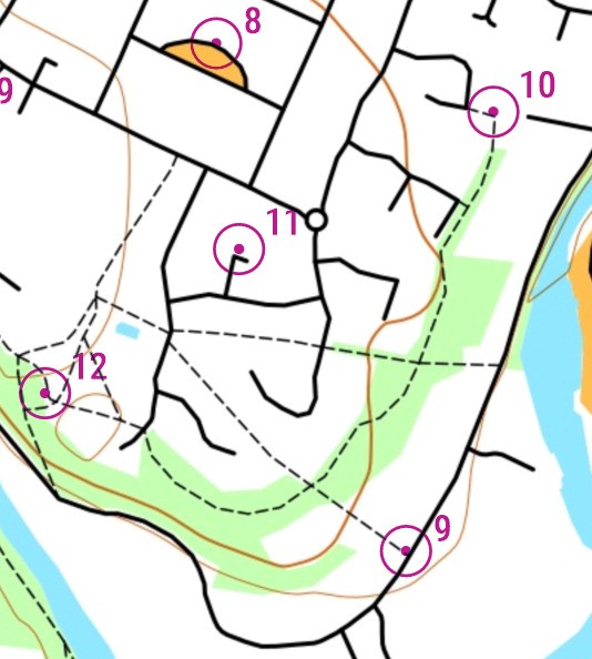
These are simplified orienteering maps mainly showing roads and paths,
also included are indications of open or wooded areas but not all are mapped.
The position of the lamppost relative to a feature(s) is indicated by a dot in the centre of the circle.
Punching Methods
To help to minimise the need for contact we will be providing two ways in which you can register your progress around the course:
- Paper Method: By recording the number on the lamppost at the centre of the control circle onto the control card provided using a pen that you must supply. Please write the answer in the box numbered for that control, ie if you are visiting control numbered 10 on the and the number on that lamppost is 123, then write 123 in box 10. After a short briefing you will be told to start. You will be timed through the finish upon your return.
- Smartphone or Garmin App Method: Using MapRun to record your progress. For those that have tried some of the MapRuns over the summer this will be very similar. If you have not and would like to give it a go then try any of the events beforehand via:
https://www.claro-orienteering.org.uk/wp/maprun-with-claro/
The course for these LampOs will be available for download in advance of the event, however you will not be able to see the course as it will be PIN protected. At the event you will find a map at your start point. On the back will be the MapRun event name and PIN number printed at the top along with any event briefing notes. The PIN number will allow you into the course once it has been downloaded and you tap ‘Go to Start’ within MapRun. When told that you can start, you will run to a point identified to you that will then record that you have started. This will also be the finish.
If when you get to a control point it does not register, this can be because you are in the wrong place or the GPS accuracy is insufficient. If the latter case then this will be awarded after the event has finished and you should carry on your course and not waste any more time.
You can choose which method you would like to use at each event up until the point of starting.