
Brimham Rocks YHOA Middle Distance Champs 24-nov-19
Results:
Please note, some of you may have noticed a negative split to the finish. This was the result of a 20 second difference between the start/finish boxes and the control boxes – so the split time from the start to the first control is 20s overstated, and 218 to the finish 20s understated. Be assured that the start and finish boxes are all in sync with each other, so the total times are accurate and it would make no difference which start or finish box you punched.
Results:
Splitsbrowser:
Routegadget:
British Orienteering:
Final Details
DIRECTIONS: Please follow Brown tourist attraction signs to BRIMHAM ROCKS. These are posted from B6165 Ripley to Pateley Bridge road and from B6265 Ripon to Pateley Bridge road. Approx. post code HG3 4DW
PARKING: We will be using the National Trust (NT) Pay and Display Car Park . NT Members can scan their membership card and park for no fee, all other cars will be charged £6 for 4 hours, payment by coins only. Please remember to bring your National Trust MEMBERSHIP Card and share transport if possible.
TOILETS: These are 400m away, North, from the car park and next to the Start. The track to the toilets/Start passes through the competition area, please stay on the track to go between the car park and the toilet/Start for any warming up.
START: 400m North of car park along a track. Please do not leave the track as it passes through the competition area.
FINISH: Within 100m of car park.
NATIONAL TRUST CAFE, SHOP & INFO POINT: These will be open from 11am to 4pm the café is adjacent to the Start and toilets.
PUBLIC: This area is visited by the public and who also may have dogs. Please be courteous.
CRAGS: All mapped crags should be considered impassable, whether shown with the standard (thinner) or impassable (thicker) crag symbol. The standard crag symbol has been used to allow detail of crags between 1 and 4m high to be shown. The impassable crag symbol has been used for crags even higher, some significantly so!
TIMINGS: Start times have not been allocated please make your way to start. Depending on your preferred start time there may be a queue.
TIMINGS:
| Registration: | 10:00 am – 12:00 noon |
| Starts: | 10:30 am – 12:30 pm |
| Prize Giving | 1:30pm |
| Courses close: | 2:00 pm |
ENTRIES: On –line entries are now closed. EOD is subject to map availability and additional charge. You can telephone the organiser to reserve a map in advance which will be held until 11:30 on the day. If you have your own dibber please bring it to registration.
• Light Green and above: Senior £7 (£10 EOD) £2 supplement for non-members. Juniors and full time students £2.50 (£3.00 EOD)
• Orange, Yellow £2.50 (£3.00 EOD)
• Maximum Family Charge £15 (£22 EOD)
• SI Dibber Hire :Senior £1 , Juniors and Full time Students 50p
• Lost Dibbers will incur a charge of £30
For EOD, if you have your own dibber, please bring it to registration.
ELECTRONIC PUNCHING: SportIdent (SI) punching will be used for all courses. Hire Dibbers will be available. Controls will be enabled for touch free punching. SIAC will be used on all the control boxes, however it will be a punching start and finish to ease the start process and for safety reasons.
NOTE SIAC Hire dibbers will not be available, only dibbers capable of handling all the controls on the course entered are available for hire.
DOGS: No dogs on courses. Dogs must be on leads and under control at all times.
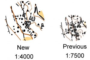
MAP: The map is 1:4000 with 5m contours printed on A4 waterproof paper by BML Printers.
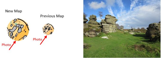
All the rock features have been redrawn and the map updated Summer 2019 to provide improved clarity of the rock detail while still allowing the contours to be seen. The large rock monoliths have been represented with the crag symbol representing the edge and filled in with the grey bare rock symbol. Boulders greater than 1m use the boulder symbol. The example below show the same piece of the new map, the previous map and a photo of that area viewed from the southwest. Note that you can now quickly distinguish between the large blocks of rock and the much smaller boulders.
 The grey bare rock symbol can represent either smooth or jagged rock. If there is no crag symbol on the edge of the grey then the rock runs in to the surrounding ground
COURSES & TERRAIN: This event is being used for the YHOA Middle distance championships. The courses have been planned more on the lines of a Long Sprint with a large number of controls amongst the rock detail, all courses stay away from the open moor. Control density is what you would expect for a sprint event.
All mapped crags should be considered impassable, whether shown with the standard (thinner) or impassable (thicker) crag symbol. The standard crag symbol has been used to allow detail of crags between 1 and 4m high to be shown. The impassable crag symbol has been used for crags even higher, some signficantly so!
THE ROCK CAN BE SLIPPERY WHEN WET PLEASE TAKE CARE. The bare rock symbol can indicate both smooth and contoured rock.
The road to the south of the map is not crossed by any course. It has been marked out of bounds and should not need to be used.
| Course | Men | Women | Length km | Climb m | No of Controls |
| Black | M18, M20, M21, M35, M40 | 4.4 | 205 | 35 | |
| Brown | M45, M50 | W21 | 3.8 | 155 | 30 |
| Blue | M16, M55, M60 | W18, W20, W35 | 3.1 | 120 | 29 |
| Short Blue | M65 | W40, W45 ,W50 | 2.8 | 105 | 25 |
| Green | M70 | W16, W55 | 2.6 | 90 | 24 |
| Short Green | M75 | W60, W65 | 2.0 | 70 | 17 |
| Very Short Green | M80, M85 | W70, W75, W80, W85 | 1.5 | 55 | 16 |
| Light Green | M14 | W14 | 1.8 | 90 | 16 |
| Orange | M12 | W12 | 1.6 | 40 | 15 |
| Yellow | M10 | W10 | 1.3 | 30 | 14 |
Loose descriptions will be available in the start lanes.
There are two places where the YELLOW and ORANGE course entrants could take paths that lead out on to the open moor. If you take these paths then after 50m you will come across a sign like below. If you do, please turn back to find the control you have just left.

The BLACK course has a two part map printed back to back. The course has 35 controls.
SAFETY: Competitors take part at their own risk and are responsible for their own safety. If travelling alone please leave your keys at registration. All competitors who start must report to download, even if they retire. The large track to the Start bisects the area and provides a safe route, South, back to the car park.
Whistles are compulsory and waterproof jackets may be compulsory in case of bad weather. The terrain is high and exposed in places – please dress appropriately.
In the event of cancellation, details will be posted on the CLARO website www.claro-orienteeering.org.uk Information can also be obtained by phoning the organiser. If you have a medical condition that first aiders should know about in an emergency, please contact the organiser in advance with details or fill in a form at registration. These details will only be used for the purposes of the event and can be collected or destroyed after the event.
Participant Satisfaction Survey
This is a Participant Satisfaction Survey sampled event; participants will be invited to share their views and comments by completing a short survey that should take no more than 8 minutes.
PARTICIPANT SATISFACTION SURVEY sampled event :Participants will be invited to share their views and comments by completing a short survey that should take no more than 8 minutes.
OFFICIALS:
| Planner | Quentin Harding CLARO |
| Controller | Andrew Kelly AIRE |
| Organiser | Susan Birtwistle CLARO 01765 677099 sueb@claro-orienteering.org.uk |
For more information visit www.claro-orienteering.org.uk