
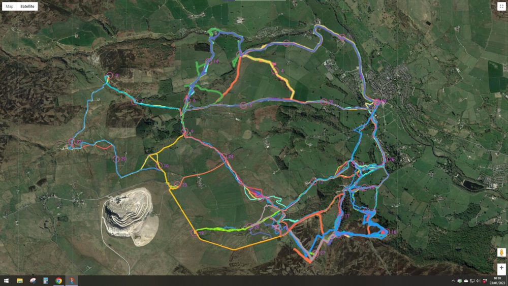
Nidderdale Treasure Hunt tracks
Results
The Maprun tracks and scores can be found at MapRun Results
A few had technical issues so from controls visited and I’ve calcualted scores below. It seems Maprun gave you 20 point just for going to the start and finish.
| Controls | Points | ||
| Stan Appleton | Claro | 15 | 340 |
| Graham Ramsden | Claro | 16 | 360 |
| Dave Tait | Aire | 11 | 260 |
And this is where everyone went …
Final Details
We will meet in the Southlands car park in the middle of Pateley – alternative parking is the long stay just 200m past the Southlands.
If you have not paid please bring cash – £3 BOF members, £5 non-members.
Don’t forget all under-16s must run with an adult.
A small change to the advertised format – the map is actually 1:16000 and there are 29 controls.
Each control is worth 20 points and there is a 5 point penalty for every minute or part minute that you are over 2 hours. You must return by 1pm.
The start/finish is at the War Memorial in the park by the bridge. Beware do not go near this before you intend to start or Maprun might start timing your run. Ensure that you go back here to end your run.
The organiser will be checking off starter and finishers – please make sure that you let me know you are running and have finished.
You will be given your map at the entrance to the park and are allowed two minutes to read the safety briefing on the reverse and should then proceed promptly to the start. The safety brief is also given below. Also on the erverse of the map are some Map Notes about specific controls and the control descriptions.

This is the QR code to download the Maprun course. Please do so in advance to avoid any phone signal issues in Pateley. If the QR code does not work for you then you can use the ‘Select Event’ feature in Maprun and navigate the folders: United Kingdom -> North Yorkshire -> Pateley -> Pateley Coldstones. To access the course you will need a PIN which will be printed on the front of the map.
After the event some of us will be retiring to the Crown pub for beer and lunch – please join us.
Start Briefing – also on reverse of map
Waterproof tops, hat, gloves, compulsory (carry if you do not wear).
You must stick to roads, or public footpaths and bridleways marked in green. Note, assuming the B6265 is still closed, you may use that but not through the works marked by crosses. A few additional permitted paths are marked in purple dashes. Any other route is cheating.
Your route is visible on the Maprun App and digressions from the permitted paths will be penalised. If you realise you have gone wrong then go back the way you came to avoid penalty.
Particularly take care navigating though farms and houses.
Do not climb walls – there are stiles and gates on the correct path.
Please take care of traffic on roads – especially between controls 1 and 2 and note there are still vehicles on the B6265.
Paths are mostly good but many will be steep, wet and slippery. Care particularly needed around control 15.
If you have any issues with landowners or others please let the organiser know asap.
If you are injured or in difficulty please call the organiser and try to get to a road or (north side of the map) the Nidderdale Way tracks below Low Wood or Hill End.
There are some extra Map Notes on the reverse of the map which only make sense when seeing the map – check these – they could be useful.
General Information
Another chance for a long run (or walk) around some beautiful footpaths in Nidderdale. It’s the same format as previous events from Summerbridge – a two hour score event where you visit as many as possible of the 30 control points marked on an Ordanance Survey 1:25000 map. The highest point on the course is at the Coldstones car park but there will be plenty of controls lower down so people can choose not to go all the way up the hill!
The map is the Ordnance Survey 1:25000 map but has been blown up to 1:15000 and a few corrections overprinted. It is the usual score format – there are 30 controls marked on the map and you visit as many as possible in the two hour period with penalties for being over time. You will need to have Maprun6 installed on your (fully charged!) mobile phone in order to register your visit to each control. You must, please, take care to stick to footpaths (or the minor roads) especially around farms and houses and use gates and stiles. Expect some muddy conditions and to paddle small becks.
PLEASE CHECK HERE BEFORE TRAVELLING. In the event of severe weather the event may be postponed.
ENTRIES: Please use the Google Form to enter. Entries close Thursday January 19th
PAYMENT: £3 per person for British Orienteering member or £5 for non-member. All juniors £1 (but must run with an adult).
Payment preferably by bank transfer to the following account or pay, in cash, on the day:
Account Name: Claro Orienteering Club BIA
Sort code: 30 93 91
Account No: 00419604
Reference: Pateley and Surname
JUNIORS: Juniors under 16 must pair up with an adult.
DIRECTIONS AND PARKING: If the weather forecast is poor please check on this website that the event is on. Parking is in the Southlands carpark or showground carpark in Pateley.
STARTS: Will be 10.30-11am. The start and finish control is close by the car park.
TOILETS: There are public toilets in the park by the bridge.
DOGS: Please do not bring dogs – many fields have sheep.
SAFETY: Participants take part at their own risk and are responsible for their own safety. All participants must return via the finish control so we know you have finished. The organisers mobile phone number will be on the map.
ORGANISER: Liz Potterton 01423 780783 or fixtures@claro-orienteering.org.uk